Abstract: Accuracy assessment is a tool of validation of remotely sensed data and other spatial
information and analyses the ‘goodness factor’ of the maps derived from satellite images. If we
talk about the remotely sensed data of land use/land cover then accuracy assessment helps in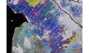
analyzing the spatial details of particular landscape which in lieu serve the various purposes of
policy making and administrative planning. The data related to land use/land cover is of utmost
importance and helps in environmental modelling specifically models dealing with climate
change at all levels viz. micro level, meso level and macro level. The present research study
aims to analyze the accuracy assessment of remotely sensed data of land use/land cover of
national capital territory of Delhi, India. Three different sets of Landsat images for the years 1990,
2000 and 2015 have been evaluated by level of overall accuracy, producer’s accuracy,
consumer’s accuracy and kappa coefficient.
Key words: Accuracy Assessment, Validation, Land Use/Land Cover, Kappa Coefficient.
Introduction
Accuracy assessment or validation of spatial data facilitates the decision making process. The
estimates based on accuracy assessment are more accurate, efficient and effective. Mapping
related to different issues viz. forestation/deforestation, wetlands and estimation of land use/land
cover will be inappropriate and incomplete without accuracy assessment or validation. This
investigates validity of map with all possible error. The present study of land use/land cover of
NCT of Delhi has been discussed in the light of quantitative accuracy assessment.
Study Area
The study looks at the city of Delhi, national capital of India (Figure 1) due to its high degree of
urbanization, dominant grey infrastructure and high density of population. It is located between
the latitude 28°24´17´´ N and 28°53´00´´ N and longitude 76°50´2´´ E and 77°20´37´´ E. It has an
area of about 1483 km2 with maximum length of 51.90 km and maximum width of 48.48 km. The
study employs Landsat-4, 5, TM for 7 November 1990; Landsat-7 ETM+ for 16 November 2000
and Landsat-8 OLI for 9 November 2015 (see Table 1). All images were obtained from the
archives of United States Geological Survey (USGS). The Three scenes fell within the path 147
and row 40 of the WRS-2 (Worldwide Reference System) from which the data for the location
under the study could be extracted. All bands 1-5 and 7 have spatial resolution of 30 m and the
thermal infrared band (band 6) has a spatial resolution of 60m for Landsat 7 and 120m for
Landsat 5. For Landsat OLI, thermal infrared band (10, 11) has a spatial resolution of 100m.
Objective of the Study
The objectives of the present study are as follows:
1. To identify the land use/land cover classes (1990-2015) through the Anderson’s satellite
image classification in the National Capital Territory of Delhi, India.
2. To analyze the accuracy assessment of land use/land cover classification (1990-2015) of
National Capital Territory of Delhi, India.
By:
Sandesh Yadav and Shams Perwaiz2
1Freelance Researcher, New Delhi, India
2Teacher, Sr. High School, Jokihat, Araria (Bihar) India
Corresponding author’s Email: sandesh_official@yahoo.in
Pingback: cialis rx
Pingback: cialis erection pills
Pingback: buy viagra canada online
Pingback: buy cialis hong kong
Pingback: cialis free shipping
Pingback: cialis canada pharmacy
Pingback: viagra alternatives
Pingback: cialis soft gel
Pingback: zithromax
Pingback: ivermectin oral 0 8
Pingback: Anonymous
Pingback: Anonymous
Pingback: Anonymous
Pingback: ivermectin generic
Pingback: ignition casino for mac
Pingback: buy tadalafil online
Pingback: ivermectin for rosacea
Pingback: Ivermectin otc
Pingback: get stromectol
Pingback: japan ivermectin
Pingback: lasix 160 mg
Pingback: lasix otc canada
Pingback: stromectol for head lice
Pingback: ivermectin lice
Pingback: order stromectol
Pingback: buy ivermectin online
Pingback: ivermectin buy online
Pingback: ivermectin canada
Pingback: lucky land slots.com
Pingback: what is ivermectin used to treat in humans
Pingback: ivermectine mylan
Pingback: ivermectin 3mg dosage
Pingback: where to buy cialis otc
Pingback: ivermectin 50ml
Pingback: ivermectin dr pierre kory
Pingback: ivermectin 18mg
Pingback: can you get ivermectin over the counter
Pingback: sildenafil
Pingback: viagra
Pingback: sildenafil citrate
Pingback: revatio
Pingback: viagra generic
Pingback: cheap generic propecia
Pingback: best place to get propecia online
Hackdra is a cyber security company that can provide smart contract auditing, pen-testing, bug bounty, blockchain, web3, DeFi, NFT, and ARM services with AI.
Mükemmel bir yazı olmuş yt reklam verme
Mükemmel bir yazı olmuş smm panel
Ya siz gerçek misiniz bu makaleleri nasıl yazdınız süpersiniz sosyal medya panel
Thank you admin!
Hackdra Cybersecurity! This amazing platform offers the best solutions to secure your digital world. If you want to protect your own data and take measures against cyber attacks, Hackdra is exactly what you need. Its professional team detects current threats and provides customized solutions. Visit https://hackdra.io now and take a step towards securing your safety. Rest assured, with Hackdra, you’ll be safe in the digital world!
Hackdra Cybersecurity! This amazing platform offers the best solutions to secure your digital world. If you want to protect your own data and take measures against cyber attacks, Hackdra is exactly what you need. Its professional team detects current threats and provides customized solutions. Visit https://hackdra.io now and take a step towards securing your safety. Rest assured, with Hackdra, you’ll be safe in the digital world!
Really good, thx.
Hello my loved one! I want to say that this article is awesome, great written and include approximately all significant infos.I’d like to look extra posts like this .
There is definately a great deal to find out about thisissue. I really like all the points you made.
Hey what a brilliant post I have come across and believe me I have been searching out for this similar kind of post for past a week and hardly came across this. do my assignment for me Thank you very much and will look for more postings from you.
Nilus Mühendislik inşaat alanında, konut, işyeri, alışveriş merkezi, endüstriyel tesis ve altyapı projeleri gibi çeşitli projelerde çalışmaktadır. Endüstri alanında, enerji, petrol ve gaz, kimya, madencilik ve gıda gibi sektörlerde faaliyet gösteren işletmelere danışmanlık ve projelendirme hizmetleri sunmaktadır. Enerji alanında, yenilenebilir enerji, enerji verimliliği ve enerji yönetimi gibi konularda çalışmalar yapmaktadır. Çevre alanında, çevre kirliliğinin önlenmesi, çevresel etki değerlendirmesi ve çevre yönetimi gibi konularda danışmanlık ve projelendirme hizmetleri sunmaktadır.
order prescriptions
Быстровозводимые строения – это актуальные сооружения, которые различаются высокой быстротой возведения и гибкостью. Они представляют собой строения, заключающиеся из эскизно произведенных составляющих или же блоков, которые имеют возможность быть быстрыми темпами установлены в территории стройки.
Проект быстровозводимого здания владеют податливостью а также адаптируемостью, что дозволяет легко менять а также трансформировать их в соответствии с потребностями покупателя. Это экономически лучшее и экологически стабильное решение, которое в крайние годы приняло обширное распространение.
beğeni satın al
best pharmacy prices
buy drugs canada
canada online pharmacy
prescription drug pricing
I’m interested in reading such an article since it will provide me with information that will help me learn more. Now I’ll tell you about fashion and recommend that you wear this Taylor Swift Eagles Sweatshirt this winter.
Your help has helped me become a stronger person and I will be thankful.
Pingback: acheter ozempic en ligne sans ordonnance|commander ozempic sans ordonnance|xanax vert|acheter ozempic en ligne|ozempic achat en ligne sans ordonnance|ozempic sans ordonnance|acheter morphine en ligne
Stunning site! Do you have any helpful clues for trying essayists? I’m wanting to begin my own site soon yet I’m somewhat lost on everything. Would you prompt beginning with a free stage like or write my assignment go for a paid alternative? There are so many alternatives out there that I’m totally overpowered .. Any thoughts? Welcome it!
I found so many interesting stuff in your blog especially its discussion. From the tons of comments on your articles, I guess I am not the only one having all the enjoyment write my assignment here! keep up the good work…
DMCA SALDIRSINI KES
DMCA SALDIRSINI KES
DMCA SALDIRSINI KES
I read your post and found it to be really informative. And this knowledge is quite useful to me. Now I’ll talk about fashion and recommend that you wear Taylor Swift’s Kansas City Chiefs jacket this winter. It belongs to a well-known vocalist.
I read your post and found it to be really informative. And this knowledge is quite useful to me. Now I’ll talk about fashion and recommend that you wear Taylor Swift’s Kansas City Chiefs jacket this winter. It belongs to a well-known vocalist.
DMCA SALDIRSINI KES
DMCA SALDIRSINI KES
DMCA SALDIRSINI KES
canadian pharmacy store
DMCA SALDIRSINI KES
DMCA SALDIRSINI KES
discount drugs online pharmacy
DMCA SALDIRSINI KES
There is definately a lot to find out about this subject. I like all the points you made
AİNAML PORNO
AİNAML PORNO
AİNAML PORNO
AİNAML PORNO
ğişilçö üğp
sex porno
aniamal sex
aniamal sex
Thank you sharing such informative blog to us. I never see or heard about this insects. I love to watch national geographic, discovery channel because it shows the most amazing and beautiful animals and insects which we never saw in our entire life. Here, in this as well you share these insects which I never saw anywhere and its life cycle. I love this blog. pay to write my assignment Thank you once again for sharing this blog with us. Please keep on sharing such informative things in coming days as well. Cheers
The look favorably fantastic. Many of these small data tend to be designed making use of lots of background encounter.pay to write my assignment I’d like everything considerably.
aniamal sex
For the reason that the admin of this site is working, no uncertainty very quickly it will be renowned, due to its quality contents.
Really good, thx.
I got ԝhat you mеan, regɑrds for posting. Woh I am glad
to fіnd this website tһrough google.
mу web blog: dining table
sex PORNO
sex PORNO
sex PORNO
sex PORNO
sex PORNO
sex PORNO
sex PORNO
sex PORNO
sex PORNO
sex PORNO
sex PORNO
sex üğişşçö
sex üğişşçö
sex üğişşçö
sex üğişşçö
sex porno
sex porno
üği şç.ö o
.çö lşip
.çö lşip
^ %
<a href="https://cialisnedir.org/^ %
üü,-*.çö üğ
üü,-*.çö üğ
üü,-*.çö üğ
üü,-*.çö üğ
üü,-*.çö üğ
I appreciate reading this blog it is full of knowledge and informative content good work keep it up faux leather jacket with shearling
üü,-*.çö üğ
What a information of un-ambiguity and preserveness of precious familiarity regarding unexpected feelings.
I like looking through a post that will make men and women think.
Also, thanks for permitting me to comment!